
Bog Hall, or Boghall*, hasn’t the same cachet as, say, ‘Larkfield House,’ or ‘Sea View’. Being more in the ‘Gasworks Lane’ vein of nomenclature.
But it’s not without interest. For it was a property on the Solway coast that vanished in time.
*(For consistency, I will stick with ‘Bog Hall,’ though like many old place names, it appears both ways).
Why the interest in Bog Hall ?
In this post and in my book ‘Port Carlisle, a history built on hope,’ I mentioned the perceived wisdom that prior to the Carlisle canal (1823), the village of Port Carlisle comprised just Kirkland House* farm and The Binnacle inn.
I have also explained why that doesn’t work for me: Hesket House (the Steam Packet) was built c1790**. And although I’ve no idea what it was called before being renamed the Steam Packet, it wasn’t ‘The Binnacle,’ which was on the site, more or less, of the present Binnacle house.
*A stone panel on Kirkland House bears the date 1729.
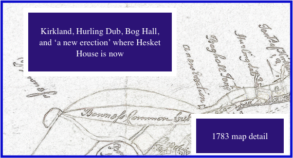
**A 1783 map ‘of the moss’ includes ‘a new erection’ at the location of the Steam Packet. And ‘Boghall Inn’ inland a little.
What the 1783 map does NOT show is The Binnacle. There DOES seem to be a building at Hurling Dub (just before Kirkland House).
Why the Steam Packet became Hesket House
The inn was run by the Peat family from at least 1829-c1866. And was for sure called The Steam Packet by 1831. The Peats next farmed at Kirkland House for a few years, before moving to (the White Ox at) High Hesket c1879.
Edward Lawson Peat and his wife Jane moved BACK to the Steam Packet between 1911-17, after he ‘declined farming’. Not wishing to run the SP as a pub either, they changed the name, picking one that reflected their previous address.
Jane remained at Hesket House until 1947, and Edward’s half-sister Annie Peat stayed their until her death in 1955.
Back to Bog Hall
17th century maps show (and name) Cardurnock, Bowness, Drumburgh and Glasson. And nothing else along that stretch of coast. But they aren’t exactly detailed.
(Cardurnock gets its name from Welsh/Cumbric ‘Caer’, meaning ‘fort’ – as in one the Romans built there. It first shows up in documents written in the 1300s. On the 17thC maps, it has a tower symbol next to it. If anyone knows anything about the tower, do please leave a comment).
1710
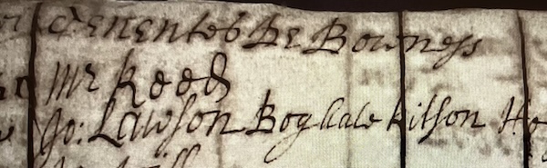
1699. The first mention of Bog Hall I’ve seen is in 1699 (‘John Lawson of Boghall’).
A circa 1765 survey has Thomas Lawson there, with three pages of fields and so on listed, including several houses, a mill, and a blacksmith’s shop.
There’s not map, but it hardly fits the narrative of ‘only two houses at Port Carlisle’.
The old maps
A 1774 map has, reading eastwards from Bowness:
- Knock Cross, Fisher’s Cross, and Kirkland. With Bog Hall set inland a little, between Fisher’s Cross and Kirkland.
Working it out from various sources, it was located a little way behind the present Methodist Chapel (built in 1861).
The old path by the chapel is a dead end today, but aerial views show a double line of hedges – an old lane running behind it.
An 1823 map of the canal has Bog Hall on it – deemed important enough to include by name when little else was.
An 1840 Admiralty map also has Bog Hall, but…
While the 1839 tithe map shows Bog Hall occupied by John Peat, it is just listed as ‘pasture’.
And an 1851 map shows the old lane/path, with two small buildings at the road end, and ‘Carlisle Railway Company’ alongside them.
After that, I’ve found nothing. Bar an 1867 ‘for sale’ listing:
To be sold: all those valuable ESTATES situate at PORT CARLISLE, and in the immediate vicinity, called BOG HALL, SOLWAY VIEW, OLD BINNACLE, and KIRKLAND HOUSE FARMS, containing altogether 235 Acres Roods, 16 Perches, or thereabouts.
It details occupiers for the last three, but there is no further mention of Bog Hall. Which MIGHT be the unnamed lot of ‘five closes of land occupied by Thomas Robinson as tenant’.
‘Just two properties’
Whatever happened to Bog Hall, after – if it was still there in 1823, the idea of there only been two properties at Port Carlisle before the canal was built really does fall apart.
I think there there were four properties, with Bog Hall being the oldest. (The others, of course, being the Steam Packet under a previous name, Kirkland House, and the Binnacle Inn).
There could even have been five: the 1783 map looks to have a building at Hurling Dub, which is between Kirkland House and Port Carlisle.
What happened to The Binnacle Inn?
Firstly, when was it built? It’s not on the 1783 map.
In 1824, Sir Walter Scott wrote ‘Redgauntlet,’ allegedly basing ‘the trysting house’ of the Scots and and English Jacobites on The Binnacle Inn.
This is according to a September 1855 newspaper article, which describes The Binnacle as:
“The little public house at Port Carlisle (until lately the only house)…”
Which it clearly wasn’t, unless you stretch ‘until lately’ back before 1783. And ignore Bog Hall totally.
To be honest, my one attempt at reading Scott was soon abandoned. But apparently the pub in the book is:
‘a large scrambling assemblage of cottages attached to a house of two storeys’.
That actually sounds just like the Steam Packet: two storeys, with cottages running down the side/behind.
For sure, by 1839, the Old Binnacle wasn’t a pub, but a ‘homestead’ – owned by William Wood and occupied by John Greenwood.
There are two Binnacle Fields on the 1839 tithe map – but they are the Bowness side of Solway View.
William Wood died in 1854, leaving his wife Mary to carry on their affairs.
Her address in 1857 was Old Binnacle, Port Carlisle. And an 1862 ‘to let’ notice makes it clear that Old Binnacle is ‘a dwelling house with a large garden’.
By 1867, when she sold the family estates, she had moved the short distance to Solway View. She then moved to Liverpool.
The ‘Kirkland and Old Binnacle estates’ were bought by Messrs S and J Lindow, for £7,500.
Old Binnacle is mentioned in a report on storm damage in January 1882, but never after.
An 1899 map shows Solway View but no Binnacle. Ditto a map from 1924.
At what point the present Binnacle (house) was built, I do not know.